If those numbers do not match, the grading inspection fails. And a failed grading inspection on a commercial property does not produce a polite suggestion to make adjustments. It produces a stop-work order, a remediation requirement, and a financial consequence that is breathtaking in its scale: tearing up finished concrete or asphalt, re-excavating the sub-base, re-grading to the correct elevations, re-paving, re-inspecting, and absorbing the delay costs while the property sits vacant and non-revenue-generating.
The cost of being off by an inch is not an inch worth of gravel. It is $50,000-$200,000+ of demolition, reconstruction, and lost time. This guide explains how that inch gets prevented: how a 2D site plan becomes a 3D surface, what technology makes that translation precise enough to pass inspection, why the sub-base determines whether the finished surface will be correct, and how the entire system—from geodetic benchmark to catch basin rim—must be verified at every stage before the irreversible step of pouring concrete or laying asphalt.
The Approved Site Plan: What You Are Building To
The approved site plan (specifically, the grading and drainage plan) is the legal document that defines every elevation on the commercial property. It is prepared by a civil engineer or Ontario Land Surveyor (OLS), stamped by a licensed professional, submitted to the municipality as part of the site plan application, and approved by the municipal engineering and planning departments before construction begins.
What the Plan Contains
A commercial grading plan includes the following critical information:
- Spot elevations: Specific heights (in metres, to two decimal places, referenced to a geodetic benchmark) at critical points across the site: building corners, entrance thresholds, parking lot corners, curb lines, catch basin rims, sidewalk intersections, and property boundaries
- Contour lines: Lines of equal elevation showing how the finished surface slopes across the site, typically at 0.25m or 0.50m intervals
- Drainage arrows and percentages: Arrows showing the direction of surface water flow, with the slope percentage beside each arrow (e.g., "1.5% →" means the surface drops 1.5 cm for every metre of horizontal distance in the direction of the arrow)
- Catch basin locations and rim elevations: The exact location of every catch basin and the exact elevation of its rim (top of grate), which determines whether water can reach it
- Curb and gutter elevations: The top-of-curb and gutter-line elevations at regular intervals, defining how the curb directs water toward the catch basins
- Accessible ramp locations and slopes: Every pedestrian curb ramp must meet Accessibility for Ontarians with Disabilities Act (AODA) requirements: maximum 1:12 slope (8.3%), with level landings at top and bottom
- Retaining wall top and bottom elevations: If the site includes retaining walls, the finished grade at the top and base of each wall segment
Every number on this plan is referenced to a geodetic benchmark —a fixed, permanent elevation reference point established by the provincial survey network or by a municipality-approved monument. All elevations on the plan are expressed as heights above this benchmark (e.g., 198.75m geodetic). This common reference system allows the surveyor, the contractor, and the municipal inspector to verify that every point on the finished site matches the approved plan to the required tolerance.
The Science of Elevation: From Paper to Ground
Translating a 2D plan into a 3D surface that matches it within millimetres requires precision survey equipment and a systematic methodology that starts before the first shovel cuts earth.
Establishing the Site Control Network
Before any grading work begins, a licensed Ontario Land Surveyor (OLS) establishes a site control network—a series of survey points across the property whose positions (horizontal and vertical) are precisely known relative to the geodetic benchmark referenced on the approved plan. These control points (typically iron bars or concrete monuments set at strategic locations around the site perimeter) become the reference stations from which every elevation on the site is measured during construction.
The surveyor shoots elevations from the geodetic benchmark to each control point using a total station or RTK GPS (Real-Time Kinematic Global Positioning System). Each control point is verified against the approved plan to confirm that the site survey and the plan are referencing the same datum. If there is a discrepancy between the existing ground elevations and the planned elevations, the surveyor identifies the required cut (excavation) or fill (material addition) at each location.
Laser Grading: The Precision Instrument
The workhorse technology for achieving site-plan-compliant grading is the laser level (rotary laser transmitter) and its advanced successor, GPS machine control.
Rotary laser systems project a perfectly level (or precisely sloped) plane of laser light across the work area. The grading equipment operator (on a skid steer, grader, or compact track loader) has a laser receiver mounted on the cutting edge or bucket. The receiver detects the laser plane and displays the cut or fill required at the machine's current position relative to the target elevation. The operator adjusts the cut depth in real time, producing a graded surface that matches the target slope within ±3mm over any 3-metre run.
GPS machine control is the more advanced system used on larger commercial sites. The grading machine (typically a dozer, motor grader, or excavator) is equipped with GPS receivers and an onboard computer loaded with the 3D digital terrain model (DTM) of the approved site plan. The GPS receivers track the machine's blade or bucket position in three dimensions (latitude, longitude, and elevation) to ±10-15mm accuracy (or ±3-5mm with RTK correction). The onboard computer compares the machine's current position and elevation to the DTM and automatically adjusts the blade hydraulics to cut or fill to the exact design surface.
GPS machine control eliminates the need for grade stakes (physical markers set by the surveyor at regular intervals showing the target elevation), reduces the number of survey verification passes required during construction, and allows the operator to see—on a screen in the cab—the difference between the existing surface and the design surface across the entire site in real time. On a 50,000-square-foot commercial parking lot, GPS machine control can reduce the grading phase from 5-7 days to 2-3 days while achieving tighter tolerances than manual methods.
"The site plan doesn't say 'approximately 198.50.' It says 198.50. That is the elevation the inspector will verify. And if nothing on your site references the same benchmark the plan does, you are guessing— and the inspector is measuring."
Critical Elevation Points: Where Millimetres Matter Most
While the entire site must comply with the approved grading plan, certain elevation points are non-negotiable and receive the closest scrutiny from the municipal inspector:
Catch basin rim elevations. The rim of every catch basin must be set to the exact elevation specified on the plan, typically 3-6mm below the surrounding finished surface grade. If the rim is too high, water cannot enter the basin and pools on the surface. If the rim is too low, the surrounding surface slopes too aggressively toward the basin, creating a dip that collects sediment and ice. The typical inspection tolerance for catch basin rims is ±5mm from the plan elevation.
Building entrance thresholds. The elevation of the finished surface at every building entrance must slope away from the building at a minimum 2% grade for the first 1.5-2.0 metres. If the surface slopes toward the building, water enters the building—a code violation and a property damage liability.
Accessible ramps and pedestrian areas. Every curb ramp must comply with AODA requirements: maximum 1:12 (8.3%) running slope, maximum 1:50 (2.0%) cross-slope, with level landings (maximum 1:50 in any direction) at the top and bottom. These tolerances are measured with a digital level during inspection, and deviations are flagged as accessibility non-compliance—a category of deficiency that most municipalities treat with zero tolerance.
Property line elevations. The finished grade at the property boundary must match the adjacent property's grade (or the municipal right-of-way grade) to prevent redirecting stormwater onto neighbouring land. This is both a code requirement and a common source of neighbour disputes and civil claims.
The Sub-Base Reality: Why the Surface Starts Underground
Here is where most commercial grading failures originate. The finished surface—the concrete, the asphalt, the interlock pavers—is the last layer in a multi-layer system. Its elevation is determined by the cumulative thickness of every layer beneath it. If any layer is the wrong thickness, the finished surface will be at the wrong elevation, and no amount of surface adjustment can correct it without tearing up and re-doing the underlying layers.
The Layer Stack (Top to Bottom)
A typical commercial hardscaping surface consists of:
- Finished surface: Concrete (typically 150-200mm for parking lots, 200-250mm for truck-loaded areas) or asphalt (typically 75-100mm base course + 40-50mm surface course) or interlock pavers (typically 60-80mm pavers on 25-30mm HPB setting bed)
- Base course: Compacted Granular A (typically 150-200mm) or High-Performance Bedding (HPB) for interlock applications
- Sub-base course: Compacted Granular B (typically 200-450mm, depending on soil conditions and anticipated traffic loads)
- Subgrade: The native soil, excavated to the required depth and compacted to 95%+ Standard Proctor Density
The total depth from finished surface to subgrade for a commercial parking lot is typically 500-750mm (20-30 inches). For heavy-duty truck-loaded areas, the depth can exceed 900mm (36 inches).
The Accumulation of Error
Each layer in the stack has a specified thickness. The finished surface elevation is the subgrade elevation plus the cumulative thickness of all layers above it. If the subgrade is excavated 25mm too deep, and the sub-base is spread 15mm too thick, and the base course is 10mm too thin, the finished surface elevation is:
-25mm + 15mm - 10mm = 20mm below the plan elevation
Twenty millimetres. Less than an inch. And 20mm across a 50-metre parking lot translates to a slope error that the inspector will catch with a level in fifteen seconds. The catch basins will be at the right elevation (because they were set independently), but the surface around them will be 20mm low, creating a dish around every basin, pooling water, trapping ice, and failing the grading inspection.
The only way to prevent this is to verify elevations at every layer, not just at the finished surface. Each layer must be surveyed and confirmed against the calculated target elevation for that layer before the next layer is placed.
Subgrade Verification
After excavation, before any granular material is placed, the surveyor shoots the subgrade elevation at a grid of points (typically every 5-10 metres in both directions) and compares them to the calculated subgrade elevation (finished surface elevation minus total layer thickness above subgrade). Any point that is high is cut. Any point that is low is filled and re-compacted. The subgrade is the foundation of the entire elevation system—if it is wrong, everything above it will be wrong.
In King City, where the rolling topography along the Humber River valley and the King Road corridor creates significant natural grade changes across commercial sites, we encounter subgrade conditions that require particular attention. The glacial till soils common to the King City area have variable bearing capacity across relatively short distances—a site can transition from competent sandy silt to soft clay within 20 metres, producing differential settlement risks that can alter the finished elevations after construction. We address this through dynamic compaction testing (nuclear densometer or lightweight deflectometer readings at a minimum grid of 10-metre centres) combined with elevation verification, ensuring the subgrade is both at the correct elevation and at the required bearing capacity before any granular layers are placed.
Granular Layer Verification
After sub-base and base placement and compaction, the surveyor repeats the elevation check at the same grid points. The top-of-base elevation is compared to the calculated value (finished surface elevation minus finished surface material thickness). A concrete parking lot with a specified finished elevation of 198.50m and a concrete thickness of 175mm requires a top-of-base elevation of 198.325m. The surveyor verifies this at every grid point before the concrete forms are set.
This is the last opportunity to correct an elevation error at reasonable cost. Adding or removing 10-20mm of granular material and re-compacting is a 1-2 hour operation with a skid steer and a compactor. Discovering the same error after 175mm of reinforced concrete has been poured and cured is a $50,000+ tear-out.
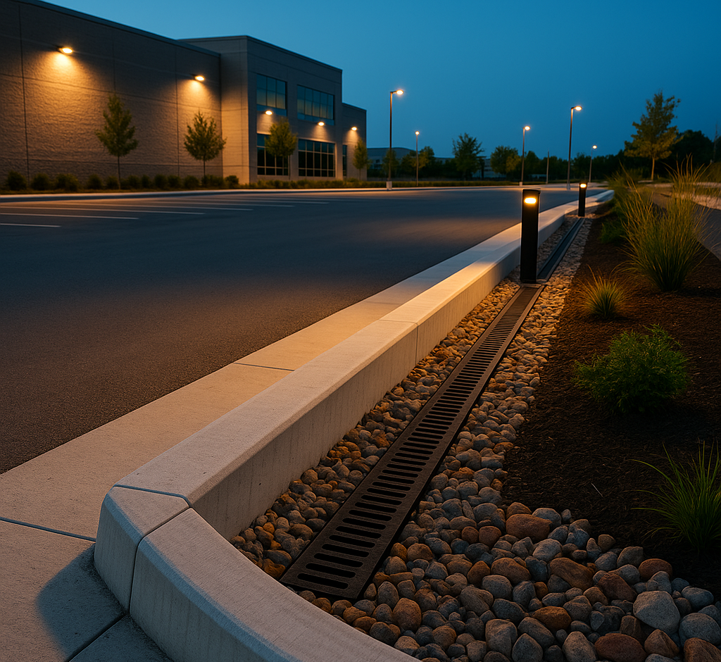
Catch Basin and Drainage Infrastructure
Catch basins are the control points of the grading system. The entire surface is graded to the catch basins—they are the low points where water collects and enters the storm drainage system. If a catch basin rim is at the wrong elevation, the grading around it fails regardless of how perfect the surface slopes are.
Setting Catch Basin Elevation
Catch basins are typically pre-cast concrete structures installed during the underground services phase (before grading). The rim elevation is set by selecting the appropriate number of concrete riser rings and adjusting the frame-and-grate assembly with shim rings to achieve the exact plan elevation. This elevation is verified by the surveyor immediately after installation and again after the surrounding surface is graded and paved.
The critical relationship: the catch basin rim must be lower than the surrounding finished surface (typically 3-6mm) so that surface water flows into the basin rather than over or past it. But it cannot be so low that it creates a depression that collects sediment, ice, or creates a trip hazard. The target: the rim sits flush with the surface minus 3-6mm, visible only if you look for it, with the surface sloping smoothly toward it from all directions at the specified 1-2% grade.
Gutter Lines and Flow Paths
Between the catch basins, the curb-and-gutter system directs water along a controlled path. The gutter grade is specified on the site plan as a series of elevations at regular intervals (typically every 15-25 metres), creating a continuous downward slope from high points (typically at the entrance or midpoint of the lot) to the catch basins (at the low points).
The gutter grade must match the plan within ±5mm. A gutter that is too flat (slope less than 0.5%) will pool water. A gutter that is too steep at one section and too flat at another creates a sawtooth profile where water accelerates, overshoots the intended catch basin, and pools at the flat section. Both conditions fail inspection.
The Cinintiriks Approach: Precision-Engineered Grading Compliance
At Cinintiriks, site plan compliance is not a final-stage hope. It is a multi-stage verification process built into every phase of construction. Our Cinintiriks Standard for Commercial Grading ensures that the finished surface matches the approved plan within the municipal tolerance at every inspection-critical point.
1. Pre-Construction Site Control: Before any earthwork begins, we engage a licensed Ontario Land Surveyor to establish the site control network, verify the geodetic benchmark, and shoot the existing grades across the site. We generate a cut/fill map that overlays the existing surface with the approved plan surface, showing the exact volume and depth of earth to be excavated or added at every point. This map becomes the grading crew's field reference.
2. Laser-Guided Excavation: All rough grading is performed with laser-controlled equipment (skid steers with laser receivers or GPS-equipped dozers for large sites). The subgrade is cut to a tolerance of ±10mm from the target elevation. After rough grading, the surveyor shoots a verification grid at 5-10 metre centres and we correct any deviations before granular placement begins.
3. Layer-by-Layer Elevation Verification: We verify elevations at three stages: top of subgrade (after excavation), top of base (after granular placement and compaction), and finished surface (after paving). At each stage, the surveyor confirms the elevation at a grid of points and at every inspection-critical location (catch basins, building entrances, accessible ramps, property lines, retaining walls). Corrections are made at each stage before the next layer covers the work permanently.
4. Catch Basin Integration: We set catch basin rims using a string-line and level cross-referenced against the surveyed control points. The rim elevation is verified at installation, re-verified after granular base placement (in case the basin has moved during compaction), and verified a third time against the finished surface elevation after paving. We target a rim-to-surface relationship of 4mm below on all catch basins—centred in the 3-6mm acceptable range, giving us a 1-2mm margin on both sides.
5. AODA Ramp Compliance: Every accessible curb ramp is individually surveyed after construction using a digital inclinometer. Running slope, cross-slope, and landing slopes are measured and documented. Any ramp that exceeds the AODA maximum (1:12 running, 1:50 cross) is corrected before the grading inspection is requested. Accessibility compliance on commercial sites is a zero-tolerance requirement—there is no "close enough" and no variance process for AODA deficiencies.
6. Pre-Inspection Survey: Before requesting the municipal grading inspection, we commission a final as-built grading survey from the OLS, which produces a grading certificate documenting the finished elevations at all specified points and confirming compliance with the approved plan. This certificate is submitted with the inspection request, providing the municipal inspector with a professional verification before they arrive on site. Our grading inspections pass on the first review because the survey has already confirmed compliance before the inspector picks up their level.
The Inspection: What the City Checks
The municipal grading inspection is the moment of truth. The inspector (either a municipal employee or a third-party engineer retained by the municipality) visits the site with survey equipment and verifies the following:
Spot elevations at specified points. The inspector checks the finished surface elevation at the critical points shown on the approved plan: building corners, catch basin rims, curb transitions, parking lot corners, and property boundaries. Typical tolerance: ±10-15mm (municipality-dependent).
Surface drainage patterns. The inspector visually confirms that the surface slopes match the drainage arrows on the plan—water should flow in the indicated direction at the indicated percentage. Some inspectors pour water from a bucket to verify flow direction at critical areas.
Ponding. The inspector looks for any area where water is visibly ponding or standing. Ponding indicates a flat spot or depression that does not appear on the approved plan and suggests a grading deficiency.
Catch basin function. The inspector confirms that surface water reaches every catch basin and enters it without obstruction. Basins with rims higher than the surrounding surface or with grading that directs water away from the basin are flagged.
AODA compliance. Every accessible ramp is checked for slope compliance. This is a pass/fail check with no tolerance for deviation.
Property line grades. The inspector verifies that no surface drainage is directed across the property boundary onto adjacent properties or the municipal right-of-way in a manner not shown on the approved plan.
If the site passes, the municipality issues a grading certificate (or clears the grading condition on the site plan agreement), and the property can proceed to occupancy. If the site fails, the municipality issues a deficiency list specifying the locations and nature of the non-compliance, and the contractor must correct the deficiencies and request a re-inspection.
The Cost of Failure: What Happens When Grading Is Wrong
A failed grading inspection is not a minor setback. It is a cascading financial event:
Demolition of finished surface: If the elevation error is in the sub-base (as it usually is), the finished surface must be removed to access the underlying layers. Concrete demolition costs $15-$30 per square metre. For a 2,000 m² parking area: $30,000-$60,000 in demolition alone.
Re-grading: The sub-base and base layers must be re-excavated, corrected, re-compacted, and re-verified. $10,000-$40,000 depending on the area and the magnitude of the corrections.
Re-paving: The concrete or asphalt must be re-poured or re-laid. $40,000-$120,000+ depending on the area and material.
Re-inspection: An additional inspection must be scheduled, which may take 2-4 weeks depending on municipal availability.
Occupancy delay: The property cannot receive occupancy until the grading certificate is issued. Every week of delay is a week of lost rent, lost revenue, and carrying costs on the construction financing. For a commercial property with monthly rental revenue of $50,000-$200,000, a 4-8 week delay adds $50,000-$400,000 in lost revenue.
Total exposure from a grading failure: $100,000-$620,000+ on a single commercial site. From being off by an inch.
Don't risk a failed city inspection and a massive tear-out. Contact Cinintiriks for precision-engineered, site-plan-compliant commercial grading and hardscaping in King City and across the GTA.
FAQ: Commercial Grading and Site Plan Compliance
What happens if my commercial property fails a final grading inspection?
The municipality issues a deficiency list identifying each location and nature of the non-compliance. The grading condition on the site plan agreement remains unsatisfied, which means the property cannot receive final occupancy approval. You are required to correct every deficiency and request a re-inspection (for which additional fees may apply). If the deficiency is in the sub-base (incorrect subgrade elevation, insufficient compaction, wrong granular thickness), the correction requires removing the finished surface (concrete or asphalt), fixing the underlying layers, and re-paving—a process that typically costs $50,000-$200,000+ depending on the affected area. If the deficiency is limited to the surface (catch basin rim adjustment, minor asphalt overlay correction), the cost is significantly lower ($5,000-$20,000). The most expensive consequence is usually not the physical correction but the occupancy delay—the period during which the property cannot generate revenue while the deficiency is corrected, re-inspected, and the grading certificate is issued. For commercial properties with tenants waiting on occupancy, this delay can cost more per week than the entire physical remediation.
Who is responsible for providing the approved site grading plan?
The property owner or developer is responsible for retaining a civil engineer to prepare the grading and drainage plan, submitting it to the municipality for approval as part of the site plan application, and providing the approved, stamped plan to the general contractor and all sub-trades. The grading plan is typically prepared by the same civil engineering firm that designs the site's stormwater management, servicing, and road access. The plan must be stamped by a licensed Professional Engineer (P.Eng.) in Ontario and approved by the municipal engineering department before any construction begins. The contractor (including Cinintiriks as the hardscaping sub-trade) builds to the approved plan exactly as drawn. If the contractor identifies a conflict between the plan and the existing site conditions (e.g., an existing utility at an elevation that conflicts with the planned surface grade), the conflict must be reported to the owner and the civil engineer for a plan revision before the work proceeds. The contractor cannot unilaterally deviate from the approved plan —any deviation, even if it appears to improve the grading, constitutes non-compliance with the approved site plan and will be flagged during inspection.
How much slope is required to properly drain a commercial concrete parking lot?
The industry standard and most municipal specifications require a minimum 1.5% slope (3/16 inch per foot) for concrete parking lot surfaces, though many engineers specify 2.0% (1/4 inch per foot) for optimal drainage. The absolute minimum permitted by most Ontario municipalities is 1.0% (1/8 inch per foot), but this is considered the marginal minimum—at 1.0%, any minor surface imperfection (form line, finishing variance, settlement) can create a local flat spot that traps water. At 1.5-2.0%, the slope is steep enough to overcome minor surface irregularities and maintain positive drainage across the entire surface. The maximum slope for a parking lot is typically 5.0% (approximately 1:20), beyond which vehicles parked on the slope experience door-swing issues and pedestrians face an uncomfortable walking surface. For accessible pedestrian routes through the parking lot, the maximum running slope is 1:20 (5.0%) and the maximum cross-slope is 1:50 (2.0%) per AODA requirements. The sweet spot for most commercial lots is 1.5-2.0%—steep enough for reliable drainage, shallow enough for comfortable vehicle and pedestrian use, and within the tolerance range where the contractor can deliver a compliant surface with standard equipment and methods.
The Final Word
Commercial grading is not about moving dirt. It is about placing every square metre of finished surface at the exact elevation that a licensed engineer calculated, that a municipality approved, and that a surveyor will verify with a precision instrument. The tolerance is millimetres. The consequence of exceeding that tolerance is a tear-out measured in tens of thousands of dollars. And the occupancy delay from that tear-out is measured in hundreds of thousands.
The system is unforgiving because the stakes are real. Water that does not reach the catch basin does not disappear. It pools on the surface, it floods the building entrance, it freezes into a slip-and-fall liability, it erodes the sub-base, and it migrates onto the neighbour's property. Every number on the approved site plan exists to prevent one of those outcomes. Match the numbers, pass the inspection, and those outcomes never materialise.
Miss the numbers by an inch, and every one of them does.